Opencartis Spatial Manager for AutoCAD Professional:
Spatial Manager for AutoCAD is an efficient plug-in tailored for AutoCAD users who work with spatial data. It extends AutoCAD’s capabilities, allowing users to import, export, transform, and organize spatial data easily and affordably. With functionality designed to manage geographic information, it also incorporates background mapping, coordinate transformation, and spatial analysis directly within AutoCAD. This tool seamlessly connects AutoCAD to a range of geospatial data sources, enhancing project workflows and data accessibility.
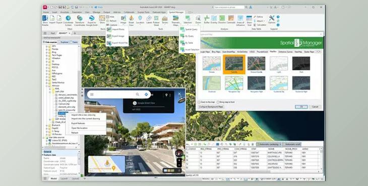
"Opencartis Spatial Manager for AutoCAD Professional" Sample:
- Spatial Data Import: Imports geospatial data as AutoCAD objects and extended metadata (EED/XDATA), applicable to both new and existing drawings.
- Data Export: Enables export of AutoCAD objects to various spatial formats or databases, with EED/XDATA preserved as alphanumeric tables.
- Coordinate Transformations: Supports geometric transformations during data import and export to maintain spatial accuracy.
- Dynamic Background Maps: Access dynamic background maps from popular providers, including Google Maps, Bing, and OpenStreetMap, with options for custom servers and Cloud Optimized GeoTIFF (COG) sources.
- Google Earth Export: Exports visible layers and data from AutoCAD to KML/KMZ files for viewing in Google Earth.
- Thematic Mapping: Adds color-coded visuals to objects based on their attribute values.
- Data Structure Management: Offers tools for editing and managing the alphanumeric data attached to objects.
- Data Grid View: A data grid within AutoCAD to view, edit, and export table data, with object selection options.
- Field Calculations: Allows calculation of expressions using table field values or constants within AutoCAD.
- Spatial Analysis: Conducts spatial operations to create new objects based on analysis of existing data.
- Drawing Tools: Streamlined tools for various drawing actions in AutoCAD.
- Image Management: Tools for efficiently handling raster images within AutoCAD.
- Geolocation Tools: Adds geo-coding features and reference elements to objects for spatial context.
- Google Street View: Integration for browsing Street View images on geo-referenced drawings.
- Enhanced Object Labeling: Labels data fields as text on AutoCAD objects.
- Terrain Wizard: Generates terrains, contours, and related objects from 3D data or elevation services.
- Import Process Automation: Allows saving of import settings for repeatable workflows.